
WARNING !
Part of the route passes through a mined area and firing/training areas. All riders should be careful not to leave or deviate from the delineated trail or cross any barriers or fences if there are warning signs. It is safe to ride the marked trails if warning signs are heeded and it is advised to follow a map at all times where these areas are shown.

Section 1 - NEVE ATIV to GADOT
THE ROUTE MAP
MAP KEY
1. Neve Ativ
2. Nimrod - Golan Trail Info Point
3. Massade - Refreshments
4. Birket Ram Lake
5. Odem Forest
6. Har Odem - Observation Point
7. Quarry - Coloured volcanic rock strata
8. Steep descent (care !)
9. Yom Kippur War Memorial/Syria view
10. Merom Golan - Accommodation
11. Har Bental - Cafe Anan - Observation point
12. Glolan Trail - Single Track
13. Har Siphon - Memorial /Observation point
14 Red Trail
15. Blue Trail
16. Views to Jordan Valley
17. Steep descent (care!)
18. Green Trail
19. Ruined customs houses.
20. Jordan River - Benei Ya'acov Bridge
21. Gadot
ROUTE ELEVATION PROFILE:
RIDE FACTS:
Start: Neve Ativ (1000meters absl)
Finish: Gadot (130meters absl)
Distance: approx. 65kms
Riding Time: approx. 6hours
Max. Altitude: 1152meters
Accum. climb: 665 meters
Accum. descent: 1524 meters
Ride Surfaces: Asphalt, double tracks, single track
Physical Difficulty: Moderate
Technical Difficulty: Moderate
Season: All year (possible mud and floods in winter)
Refreshments: Available on route
Water: Available on route (carry at least 2 litres)
Cycle Suitability: MTB, Touring/CX, Road !


THE RIDE :
The Israel End to End Bike Trail starts at an elevation of 1000 meters on the lower slopes of Mount Hermon, and it will have another approximately 900 kilometers to run before it hits the warm blue waters of the Gulf of Eilat ! The Trail is unique for a cross-country cycling route in a small country because of the variety of landscapes, topography, and riding conditions encountered, plus the multitude of remarkable sites taken in.
This first section is no exception. Riding the basalt plateau of the Golan Heights offers wide vistas in all directions ; the Syrian plain to the east, the Hullah Valley, part of the Great Rift Valley, and onwards to the Galilee Mountains, in the west. The route covers rocky tracks, extinct volcanos, quiet country lanes through fruit orchards, and ravines of gushing waters, and sites of ancient and more recent history, all within a 65 kilometer length.
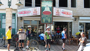
The trail starts at Neve Ativ, a village on the slopes of Mount Hermon, and the atmosphere is definitely alpine-like. The trail first ascends on a back road to the settlement of Nimrod, named after the Crusader Castle, which can be seen northwards on a magnificent rocky escarpment. The route then follows the green, blue, and white markings of the Golan Trail to the little lake of Birkat Ram which may have been the crater of an extinct volcano, but is now a placid pool of water surrounded by fragrant fruit trees with a backdrop of the snow clad summit of The Hermon. It is recommended to a take a break at a cafe in the Druze village of Mas'ade to sample their local speciality energy bar, Knefe , a pastry of cheese and sugar!
The subsequent ride is through the Odem Oak Forest, cow pastures, and orchards , then scaling the volcanic peaks of Har Odem, Hermonit, Har Bental and Har Siphon. Don't miss the the multicoloured rock quarry below Har Odem. It is also a journey through the relics of military conflict. Scattered on either side of the tracks are the scars of battles past, shattered bunkers, uncleared minefields, and memorials to the fallen soldiers. If time permits, it is worth a detour to climb Har Bental from the village Merom Hagolan. At the summit are bunkers and fortifications, a great view to Kunietra in Syria, and a cafe, named 'Coffee Anan', a cute hebrew word play on a certain ex- UN Secretary General !
The climax of this first section is the final descent from The Golan to the Jordan River, 800 metres below. This is a great MTB experience, quite technical in places, and care has to be taken on the steep rocky trails. If in doubt, it is best dismount and take some photos of the magnificent view down to the Hullah Valley. The trail exits on to the highway, and after passing the ruins of the old Syrian Customs House, the Jordan River is crossed on the Bnei Ya'acov Bridge, there is then a road climb to Kibbutz Gadot, where the section ends.

The View to Nimrod Castle from the Golan Trail

Birket Ram Lake
Kenefe Cafe, Mas'ade

Riding in the Odem Oak Forest

The Descent to the Jordan River

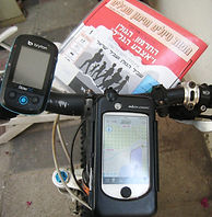
MAPS and GPS:
Paper Map: SPINI Israel Touring & Hiking #1 (Hebrew)
SmartPhone Map Apps for Israel (Hebrew OS): Amudanan,
GPS Files of Section #1 (gpx, kml): GPX-View.com
Amudanan and Shvilnet provide detailed Israel maps (in app-purchase) and a GPS location service. GPX file import is not supported. TopoMap is an Israel phone app with route GPX import and SPINI Trail Maps available via in app-purchase
Other navigation phone apps (e.g. MotionX, ViewRanger, MyMaps, Cyclemeter, Bike Tracks) are available to import route GPX files, or a dedicated GPS Unit such as Garmin Edge can be used. Be aware that these apps only provide OpenSouce Mapping such as OpenCycleMaps or Google Maps, which are less detailed than local mapping.
Please note: It is best to ride with both a detailed Israel map (paper or app), and with a separate navigational GPS device.
ACCOMMODATION:
-
Start- Neve Ativ (B&B Guest Houses, Hotel)
-
Finish - Kibbutz Gadot Country Lodging.
TRANSPORT:
The trail head at Neve Ativ can be reached from Kiryat Shemona by public transport using the Golan Bus (line #58) or by private taxi.
The national bus company,Egged (bikes carried free), have regular services to Kiryat Shemona from all the major centres in Israel.
Golan Bus, Kiryat Shemona Bus Station
For further information on riding the Israel End to End Bike Trail, contact:
Return to the Israel End to End Bike Trail
Please Note: The author of this proposal is not responsible for any changes encountered in the field, any innacuracies in the GPS data provided, or encountered during navigation of the proposed route.